How are Earthquakes Measured?
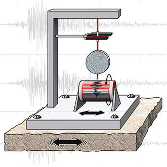
Geologists use seismographs to record surface and body waves. When motion is recorded, a seismogram is created, which tells how big the waves were and how long they lasted. Using several seismograph stations records, the epicenter and focus can be located through triangulation.
Earthquakes can be quantified in several ways. The first way is to describe the earthquake's intensity. Intensity is the measure of damage to the ground surface and the effects on humans. The most common scale is the Modified Mercalli Scale, which uses a twelve-point Roman numeral scale to describe damage. While intensity helps determine the extent of the damage, it is not an objective measure of the actual earthquake size, because the intensity can vary greatly in the same area due to different geologic conditions.
The second method of measurement is the magnitude of the earthquake. Magnitude depends on wave amplitude and distance measured from seismograms. The most common scale is the Richter scale, which measures the magnitude on a logarithmic scale.
The third type of measurement is called the seismic moment. Using seismic waves and field measurements that describe the fault area, the seismic moment, a parameter related to the angular leverage of the forces producing slip on a fault, can be measured. This moment is related to a corresponding magnitude known as the moment magnitude. This type of measurement gives a consistent and uniform measure of the size of an earthquake of any magnitude anywhere in the world and is considered very accurate because it takes into account fault geometry.

Source: Wikipedia, https://en.wikipedia.org/wiki/Seismometer